 Severe weather is not a common concern, although every eight or nine years a cyclone will come through the islands wreaking serious damage. Flooding landslides and losses of life at sea are the usual result. New Zealand sits on two tectonic plates - the Pacific and Australian and some parts of the South Island while the rest of the South Island sit on the Pacific. It is seismically active. When we were on the South
Island I felt the effects of one of their frequent earthquakes
Over thousands of years, through the process of subduction, parts of the coastal mountains become submerged, creating impressive sounds and fjords. In Milford Sound we saw a good example of this which I cover in a later post. Needless to say the channels offer some of New Zealand's most picturesque scenery.
 We flew, drove and and took bus and boat tours to see the length and breadth of this island. A week of course is not enough, but it did provide a cross section of what the South Island had to offer. You do not have to go very far before another photo opportunity would present itself. Unlike the north island, the population density is significantly lower making for frequent and prolonged natural landscapes as we traveled.
The "southern alps' constitute the back bone of the island. Travelling east to west means a mountain pass or two is required. Glacial fed lakes, impressive mountain vistas and untouched wilderness reminded me of much of British Columbia. Both share a common heritage as the mountainous terrain represented a daunting obstacle to early road and rail construction.
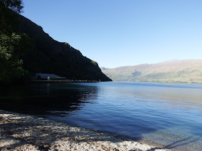
The last two photos are from the beach of our rental property in Kingston in the interior of the island. This small, rather remote setting was the staging point for our tours and ventures out to points of interest. It served as a peaceful reprieve from the throngs of tourists in the larger centers.


No comments:
Post a Comment